Day 15 – June 23, 2016
Mileage – 77,048
Yosemite National Park, CA – 10 Miles
We packed a lot in today.
Our goal is to get an early start, first stop the Park Service Reservation Office to see if there is a campsite available in the park for the night. We pull up stakes in 45 minutes; the alarm goes off at 6:50am and we are on the road by 7:35am. We arrive a little Wowona at a little before 8am, taking the chance to review the park information before they open. No success. They only campground that takes RVs who has sites is in the northern district, a 2 hour drive and we would need to be there now to make the reservation. No worries we will sleep in the NFS land outside the northern park entrances either to the east or west. The ranger at the reservation desk gives us a few ideas – basically go see Yosemite Valley and Glacier Point. We don’t heed the later, passing by the pull-off (remember that decision). This Ranger is enthusiastic, but it’s obvious she doesn’t get many opportunities to give advice on the park. She seems tickled pink to be asked.
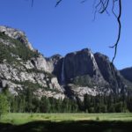
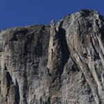
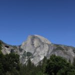
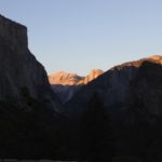
And we are off to see Yosemite Valley. We get our first moment of panic as we pass glance at a sign speeding into the first tunnel that says the height is 10ft 2in – we are just shy of 11ft. Jenney closes her eyes and holds her breath. Peering through slits the tunnel is a natural wonder, cut straight from the granite, sides rough and notched, you can almost imagine pick axes and hammer carving through the mountain. We emerge into the bright sun and a magical land – before us is El Capitan, Half Dome, and Bridalveil Falls all in one view. You can almost imagine what it would have been like to be one of the European explorers stopping here. At that time the valley floor would have been mostly meadow, kept clean by the Native Americans/First Nations people who called this valley home. We are swept with both a sense of awe and weight of knowing how history unfolded with the genocide of native people. There is sense of loss as we realize that much of story that is told of the parks lacks the full history of these lands, focusing predominantly on European settlement and the Park Service’s centennial. We take it all in.
It’s early so there aren’t too many people yet. We head toward the visitors center, passing through the general store to grab a few things for lunch. It’s a full grocery store and a bit of a mad house. After a week in more remote parks it’s a bit overwhelming. Next stop the post office for more stamps, which is like stepping back in time. Sleepy inside compared to the hustle and bustle of Yosemite village, peace returns. The post office smells and feels like something from 75 years or more ago. All of the post boxes are wooden and there is one window with a friendly hometown type post worker.
On the way in there is a poster of the amazing photo taken by postmaster as an advertisement for a showing of his work. It makes you realize the complexity of the people who are the engine behind the parks often following a passion that leads them to the park. Is the friendly man who sold us our stamps, this amazing artist?
We stop into the visitor center. We have come to realize that there are different types of rangers who staff the desks – friendly, gruff, passionate, informative – and realize finding the right ranger can set course for an amazing day as in Bryce Canyon. It takes a huge amount of talent to listen to the guest in front of you, assess their individual needs, and set them on course toward their individualized adventure, and to do it quickly, over and over throughout the day. Today we have a young enthusiast Ranger who we can tell both loves his job and who would rather be outside exploring the park himself. He is like a fun loving puppy bouncing all over the map, “it’s all amazing!”. He has a few good hints, but we leave knowing we need to narrow down the scope. He mentions Glacier Point, but we discount this advice due to the drive. He also loads the girls up with Junior Ranger material to get badges and patches galore.
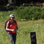
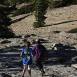
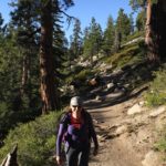
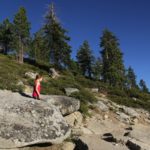
Logan helps set the course by definitely saying we should start with the long hike first, about 6 miles starting at Bridalveil Falls. Heeding her advice we hop on the bus hoping to get to our destination and on our way. The bus driver stops at the second stop saying we will be here about 5 minutes; Jenney almost groans out loud. He mentions that often you can see climbers from this vantage spot and is the first off the bus with his binoculars. Occupants trickle off looking up at the cliffs. Five minutes pass, when are we going to get going. Finally giving into the urge to see what is so fascinating up the cliff, Jenney and Kevin meander off; sure enough a tiny speck on the cliff is a team of climbers almost mesmerizing to watch dangling off the edge of the world. Lured away from the Junior Ranger books, the girls along with a throng of other riders join the crowd to look up. The bus driver is full of facts about climbing El Capitan – again who knew.
Bridalveil Falls bus stop, do you follow the crowd up to the falls or start the hike? You get the sense of what it must be like to be a lemming; the pull of not wanting to miss what everyone else is seeing is strong. We head to the viewing area of the falls. It’s crowded, teaming with people. We almost run back hoping that the trail will afford a bit more solitude. On the way, a young buck crosses the path to get to stream, he almost seems dumbstruck by the crowd; Jenney can relate.
The first quarter of the mile on the trail brings a few groups of people and then the crowd falls behind and it’s a walk through an amazing valley with sheer granite cliffs and waterfall around most corners. Teryn makes a face plant into the trail, but quickly recovers. Road workers below offer call up cheerful offers to help. Jenney follows with a stumble to all fours. We all laugh it off.
Miles disappear into great conversation as the girls propose that they would like to go on a solo-backpacking trip together. Many summer plans are hatched involving a myriad of people back home, yet to be informed of pending adventures.
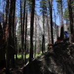
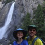
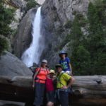
Soon it’s time for lunch atop a granite slab in full view of Yosemite Falls. There is something magical here.
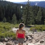
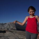
Six miles or more disappear quickly. Along the trail we stumble into the XXX house by accident, originally the visitor’s’ center and now the home of the Sierra Club. Two volunteers staff the building, with contrasting personalities; there is the bubbling grandmother adventurer still working to grab all the high peaks and recounting her years travelling with he four children and the reserve academic willing extol on her career and 3 masters degrees and a doctorate. It’s a comical contrast. The first volunteer is passionate about the park. She gives us some great hints, warning us away from a steep slippery hike we had planned, and steering us back to a lesser-known hike, sentinel dome, up near glacier point. She is the third person to make this suggestion and the most compelling and knowledgeable about the park, so now we are paying attention.
We realize we have headed a bit off our original path, we must have missed turn to have ended up with the Sierra Club women and have gone farther up the trail. Somehow we need to weave back to Yosemite Village to get to the Yosemite Falls. We stumble into the maze of a different world in the parks, a tent city – the Pines campground. Again it feels like a time warp, these are canvas tents set up by the Park Service. It’s hustle and bustle of happy vacationers; it reminds Jenney of what it must have been like in the 50’s era Adirondack family summer camps.
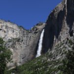
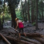
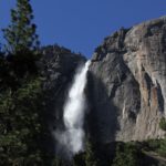
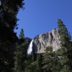
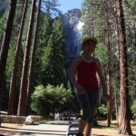
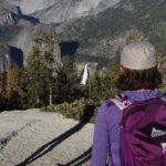
A bridge across a river brings us back to a quieter trail leading back to the Village. A quick stop at the RV for a fresh camera battery and we are off again to Yosemite Falls. At this point we have lost track of the miles we have walked; it’s a long way. Adding to that we walk from the Village to the Falls loop, the loop alone is a mile of forested paved path. The reward, a view of both lower and upper Yosemite Falls, it’s worth the extra steps. Energy is high, the girls skip from granite boulder to boulder and walk atop stone walls, Teryn leading the way. We have gone over 8 miles.
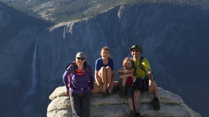
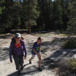
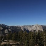
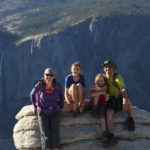
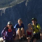
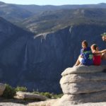
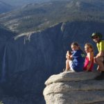
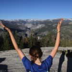
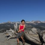
It’s 5pm, decision time, do we back track to go to Sentinal Dome, another 2.2 mile hike on Glacier Point or go out to the north section of the park. Three park staff have pointed us toward Glacier Point, the last saying that most of the quintessential park photos are taken here. The only concern is whether another 2.2 miles is doable; it would push us over 10 miles almost twice our usual distance. We only live once, and the girls vote yes.
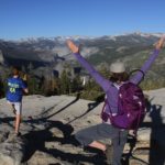
We aren’t sorry. It’s a moderate hike with a scramble up a granite dome at the end, but the views – stunning is an understatement – El Capitan, Half-Dome, Yosemite Falls, the glaciers, and several other large falls. It’s a full 360 degree panorama. “WOW!” is all we can say.
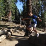
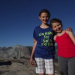
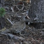
Teryn is the energizer bunny, running down the mountain. The girls are playful with each other. The mood is high. Kevin finds the elusive, camouflaged chicken like bird we couldn’t find in the Rockies. We are going to have to look it up again.
Now it’s time to get serious about finding a place to sleep. The northern tier of the park is out. It’s almost 8pm, finding sites in the dark isn’t always easy. We recalibrate to sites along rt 120 and set course. By the time we get to our site for the night, Teryn is done; she has run out of steam. Food and bed are a priority and then she is out for the count. Over 10 miles of hiking brings a close to the day in a secluded pine grove in the middle of nowhere California. Perfect day!
-

- Campsite, Yosemite National Park, CA
-
- Campsite, Yosemite National Park, CA
-

- Campsite, Yosemite National Park, CA
-
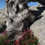
- Meadow by Campsite, Yosemite National Park, CA
-

- Woodpecker, Yosemite National Park, CA
-
- Woodpecker, Yosemite National Park, CA
-
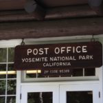
- Post Office, Yosemite National Park, CA
-
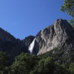
- Yosemite Fall, Yosemite National Park, CA
-
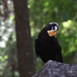
- Raven, Yosemite National Park, CA
-
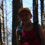
- Teryn, Yosemite National Park, CA
-
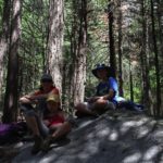
- Lunch, Yosemite National Park, CA
-
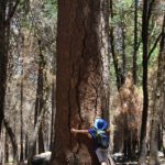
- Hug a tree, Yosemite National Park, CA
-

- Yosemite National Park, CA
-
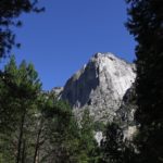
- El Capitan, Yosemite National Park, CA
-
- Lunch View, Yosemite National Park, CA
-
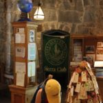
- Sierra Club, Yosemite National Park, CA
-

- Sierra Club, Yosemite National Park, CA
-
- Yosemite National Park, CA
-

- Yosemite National Park, CA
-
- Yosemite National Park, CA
-
- Yosemite Falls, Yosemite National Park, CA
-

- Yosemite Falls, Yosemite National Park, CA
-

- Yosemite Falls, Yosemite National Park, CA
-
- Yosemite Falls, Yosemite National Park, CA
-
- Yosemite Falls, Yosemite National Park, CA
-

- Yosemite Falls, Yosemite National Park, CA
-
- Yosemite Falls, Yosemite National Park, CA
-
- Yosemite Falls, Yosemite National Park, CA
-
- Yosemite Falls, Yosemite National Park, CA
-
- Yosemite Falls, Yosemite National Park, CA
-

- Yosemite National Park, CA
-

- Yosemite National Park, CA
-
- Yosemite National Park, CA
-

- Yosemite National Park, CA
-
- Half-Dome, Yosemite National Park, CA
-
- Yosemite Falls, Yosemite National Park, CA
-

- Yosemite National Park, CA
-
- Yosemite National Park, CA
-
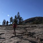
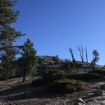
- Sentinel Dome, Yosemite National Park, CA
-
- Sentinel Dome, Yosemite National Park, CA
-
- Sentinel Dome, Yosemite National Park, CA
-
- Sentinel Dome, Yosemite National Park, CA
-
- Sentinel Dome, Yosemite National Park, CA
-
- Sentinel Dome, Yosemite National Park, CA
-
- Sentinel Dome, Yosemite National Park, CA
-
- Sentinel Dome, Yosemite National Park, CA
-
- Sentinel Dome, Yosemite National Park, CA
-

- Half-Dome from Sentinel Dome, Yosemite National Park, CA
-
- Sentinel Dome, Yosemite National Park, CA
-
- Sentinel Dome, Yosemite National Park, CA
-
- Sentinel Dome, Yosemite National Park, CA
-

- Sentinel Dome, Yosemite National Park, CA
-
- Sentinel Dome, Yosemite National Park, CA
-
- Sentinel Dome, Yosemite National Park, CA
-

- Sentinel Dome, Yosemite National Park, CA
-
- Sentinel Dome, Yosemite National Park, CA
-
- Sentinel Dome, Yosemite National Park, CA
-

- Sentinel Dome, Yosemite National Park, CA
-
- Sentinel Dome, Yosemite National Park, CA
-
- Sentinel Dome, Yosemite National Park, CA
-
- Sentinel Dome, Yosemite National Park, CA
-
- Sentinel Dome, Yosemite National Park, CA
-
- Bird at Sentinel Dome, Yosemite National Park, CA
-
- Sentinel Dome, Yosemite National Park, CA
-
- Sentinel Dome, Yosemite National Park, CA
-
- Sentinel Dome, Yosemite National Park, CA
-
- Sentinel Dome, Yosemite National Park, CA